Angaston Bakery Run
- gbulling2
- Sep 4, 2022
- 7 min read
Updated: Aug 3, 2023
The second of our bakery runs follows a route through the Barossa Valley culminating with visit to the Sunrise Bakery in Angaston.

Where do we start?
This ride begins and finishes at Tea Tree Gully in the North Eastern suburbs of Adelaide.
The gpx route begins at the intersection of Haines and North East Rd, nice and close to the Fox and Firkin British Pub

Route overview
This route follows a variety of different roads and tracks from generally short sections of bitumen, through lots of flowing gravel roads as well as a number of 'Dry Weather Road Only' type secondary roads/tracks. These are often well named so a word of warning - they do become very slippery/boggy after rain!
In total. the route covers a distance of 170 km

Let's go!
The first part of the ride heads up North East Rd

before peeling off onto Range Rd North and then immediately right again down Lower Hermitage Rd. This is a great section of road that weaves its way through some fantastic countryside

It passes Glen Ewin Estate

and there are often plenty of 'roos feeding in the grassy paddocks along the road


After passing the intersection with Millbrook Rd, the width of the road (and the speed limit) reduces

before it winds it's way uphill

to a T-junction, which has Hannaford Hump Rd heading left and Airstrip Rd to the right. It is to the right that our route follows, along a hard packed gravel surface.

Views of the coast to the west poke out over the paddocks

as we follow the edge of a section of Mt Crawford Forest Reserve. This area has a multitude of fire tracks and the fences are often breached by 4x4's breaking through.

so much so, that the powers to be have resorted to lining up large boulders along highly hit areas of the fence.

a little further along a more open area can be seen on the northern side of the road which is the site of an old airstrip (hence the name of the road). It also plays a sad part in our State's history, as it was near this airstrip that the body of Richard Kelvin was found 1983, one of the victims of the infamous 'Family Murders'

The last section of Airstrip Rd heads steeply uphill before it meets Mt Gawler Rd

It's then not long before a short section of Kersbrook Rd is followed

before we turn off to our right along Karwin Rd and into Humbug Scrub territory (be careful at the turn off as it's on a downhill bend and can cause some anxious moments if it's necessary to wait in the middle of the road for on coming traffic to pass).


This leads past a number of small side roads that copped the brunt of the Sampson Flats fires in 2015. A monument to the firefighters is passed along the way.


It continues to wind along until the bitumen is reached as it intersects with Humbug Scrub Rd

This section passes Para Wirra Conservation Park on the left

which is well worth a visit if walking and/or cycling are one of your interests

eventually Humbug Scrub Rd veers sharply left on a downhill bend and the South Para River is crossed

it's also a spot to find your Ford Falcon if it's gone missing!

Once over the river the road heads steeply upwards before intersecting with the the dirt at Para Wirra Rd. Our route has us turning left and skirting along the edge of the Barossa Reservoir Reserve.


After heading down Green Gully Rd

the reservoir can be glimpsed at several spots along the way

The dam wall of the reservoir is known as the 'Whispering Wall' due to it's unique acoustic properties. With it's concave design a parabolic effect enables voices to travel clearly from one side of the wall to the other, a distance of over 140 m. Although not on the route, it's a 3km side trip to visit the wall and a waypoint is included in the gpx file.

soon we hook up with Goldfields Rd

that takes us through to the bitumen at Balmoral Rd

those looking for some spiritual nurturing can pop in along the way (if you're a Chrisdadelphian of course..)

otherwise it's off down Kalperri Rd which is found on a wide sweeping bend overlooking Gawler to the west


This road links across to the Barossa Valley Way and crosses the Barossa Trail, a cycling and walking track that runs from Gawler all the way through to Angaston

A few 100 meters across from where Kalperri Rd meets the bitumen we turn off down Mugge Rd.

This was the site of a siege back in 2021 when police tried to conduct a firearms audit on a "sovereign farm". Needless to say it all went a little pear shaped..

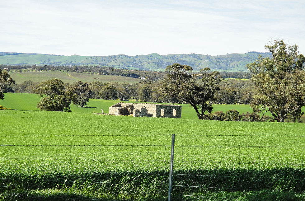
We now head north towards the Barossa Valley

past ruins and green crops
after a bit of a dogleg we pick up Winton Rd, the first of a number of roads that can get a little nasty after rain. It was all good on this ride but I've had a slippery time on other occasions!

near its end it crosses over a small offshoot of the North Para River which can cause a few issues if it's been really wet.

Once through the boggy crossing the surface improves as it becomes Dalgety Rd then Dahlenburg Rd, before it soon joins up with the bitumen at Rosedale Rd.

Its then through the small town of Rosedale


where the North Para River is crossed

Once past the town, a turn off down Eckermann Rd provides the sight of something a little unusual.

A elevated BMW (an early 90's K75RT I think?) taking pride of place at a farm entrance.

once past the BMW the road cuts through and comes out at Rosedale Rd.

where we pass Pindarie Winery. A nice spot to while an afternoon some time in the renovated grain room and stables that now house a cellar door and lunch venue with great views out to the valley

Gomersal Rd is our next turn off as we head into the heart of the valley

The route now zigs and zags a little starting with a turn off down Brauack Rd

and then picking up "Dry Weather Road Only" tracks
its great riding through a variety of different tracks, some rarely used and grassy.


but you always need to be on your toes to ensure you pick up any slippery sections that can become a handful at speed.


at one point we pass the property where Norm Keat ran for many years a famous performing sheep dog show.

The shows ended in 2014 when he was 90 years old.

but not before a little controversy!

After passing Norm's old place our last few tracks get a little tricky.

but soon we hit the gravel once more

and pop out on Seppeltsfield Rd near Whistler Winery

this leads us between Tanunda and Nuriootpa, passing Chateau Dorrien

before we make our way into Angaston

and our target - Sunrise Bakery!

There are also Sunrise Bakeries at Gawler, Truro and Lyndoch but the baking for all the stores occurs at the Angaston shop. I've visited them all over the years and the quality has generally been pretty good. This visit was on a Sunday and there wasn't much variety left in the pie warmer, so I settled for a standard mince pie.
My score for the pie was:
Pastry - a little doughy 7/10
Filling - tasty 8/10
Temperature - perfect! 10/10
A few negatives - the service was pretty slow (albeit they had some inexperienced staff working), way too much sauce on the pie and they don't stock coke!
Overall though, it was pretty good experience and the outdoor seating area is excellent with plenty of room to spread out and parking out the front.

after digesting lunch it was off again, beginning with a section of Stockwell Rd

before we headed up Mengler Hill Rd

which is a favourite of the Tour Down Under cycle race when it runs through the Barossa area.

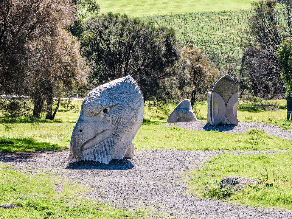
about 1.5 km up the hill there is a turn off to a lookout that has panoramic views of the local area.

the Barossa Pioneer Memorial

and a sculpture park, where you can wander through a number of large artworks.
after taking in the views it's then off to the top of the hill and down Tanunda Creek Rd


past some impressive farms

before the gravel is taken down Rocky Rd.

This really is an area of 'big' trees

with some impressive examples lining the road

soon we weave our way along several back roads until we pick up Peggy Hill Rd.

This area is a favourite of mine with nice flowing roads


and the occasional wet spot

it's easy to miss but our next turn off is through a nondescript gate that is not signposted

although a gazzetted puplic road (Karra Yerta Rd) there is some grazing going on.
It's important that through this section (and other section like this on routes I put up) riders are very aware of their obligations to"do the right thing". This really means taking it nice and slowly and keeping the noise and impact to a minimum. If we do this we can continue to ride such areas without push back from landowners and councils.

once past our first obstacle

this great track runs through some native areas

between a number of paddocks

and often includes some wet areas in winter (once again take it easy to avoid impact)

eventually the road changes name to Odgers Rd and exits at the Heggies Boundary/ W.Pumpas Rd intersection.

A side track well worth taking, is up Three Cols Rd to check out the Eden Valley Scenic Lookout

Here you can get an expansive view of the Eden Valley and surrounds


It's most striking feature is a massive (6.8 mt) cross that takes centre stage.

There's even a guide to help view some local (and more distant) landmarks

We now begin heading west back towards our starting point. Beginning with Cranes Range Rd.

Through the tiny hamlet of Craneford

before we branch off down High Eden Rd

the run through this area is very pleasant

and also includes Corryton Park Rd

where more flowing sections are found

it concludes at the intersection with Trial Hill Rd but unfortunately Ross Fire Track that heads off across the road is not accessible

As we travel west the Corryton Park Homestead can be seen on the right of the road. This is part of the Corryton Burge Wine Estate

with the impressive gates passed on a sharp bend of Wirra Wirra Rd

After crossing Springton Rd we continue down Mount Rd and pass into the Mt Crawford Forest Reserve. There are a number of campgrounds passed as well as the old cemetery.


Soon we reach Forreston

and then turn off down Alexander Forest Rd for some great views back across the ranges

the T - junction at it's end meets Norsworthy and Hill Roads

it was at this sharp bend in 2009 that a terrible crash occurred during the Classic Adelaide Rally claiming the life of the driver and navigator when their Porsche hit a tree.

It's not long before we skirt the edge of Kersbrook along Smith Rd (fuel is available there if needed)

then up along Adelaide Gully Rd

watch the sharp left hand bend where it meets Bagshaw Rd!

then it's into Inglewood

and up Blackhill Rd (directly opposite the pub)

there's a few locals

and speed humps

before the road tracks down into Houghton Square

we sneak across Lower North East Rd and down into Houghton Hollow


before completing out route down North East Rd to the bottom of the hill where
"The Gully" pub lies.

I hope you enjoyed the ride! (Comments are welcome)
A download for a gpx file of the route can be found below.


Went on this route today, had a great time. Thanks for sharing your GPX